Gippsland Environment Group Inc
Lobbying against environmental threats on the unceded lands of the GunaiKurnai, Yaitmathang, Ngarigo and Bidwell Peoples
Providence Ponds Flora and Fauna Reserve
Post burn Survey Report
June 2025
Forest Fire Management Victoria
Burn: Fernbank - Fernbank Tk | GP-MAC-BRI-0074
FIRE DISTRICT: Macalister, Gippsland
Total area: 80ha | Area treated 46ha | Ignited 12 May 2025
Background
On GunaiKurnai Country, on the Gippsland Plains between Bairnsdale and Stratford, is the Providence Ponds Fauna and Flora Reserve. It is approximately 2000ha in area. The Reserve supports the lower reaches of a long chain of ponds network, that begins in the foothills and becomes the Perry River at Perry Bridge, flowing into the Gippsland Lakes.
In 1952, it was declared by botanists that rare flora specimens at Providence Ponds were found nowhere else in the world. In 1954, 45 acres was reserved to protect rare flora (Gippsland Times 5 April 1954). This was later expanded following the 1983 Land Conservation Council Final recommendations for the Gippsland Lakes Hinterland.
Intersected by the Princes Highway and surrounded by cleared farmland with tree plantations to the north, this bushland reserve is an isolated and precious remnant of old growth coastal banksia and peppermint woodlands intersected with swamps and sedge wetlands. Growing predominantly in dry and seasonally inundated, sandy soil, this ecosystem represents an increasingly rare habitat type.
Providence Ponds Flora and Fauna Reserve is one of only five known locations in Victoria of the nationally threatened New Holland Mouse, Pseudomys novaehollandiae.
Below: Ancient banksias. Providence Ponds Fauna and Flora Reserve May 2025

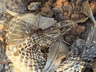
A copperhead shed its skin in the hollow of the old banksia

The Burn
This 80Ha Forest Fire Management Victoria (FFMV) planned burn is bordered on one side by the Princes Highway and the other side, by cleared farmland. The road on the north boundary of the burn is Mouse Track - so named for the nationally threatened New Holland Mouse/Pookila that lives here.
The burn was in an area of Heathy Woodland with records of New Holland Mouse, Pseudomys novaehollandiae (EPBC VU), White-footed Dunnart, Sminthopsis leucopus (FFG VU), Variable Bossiaea, Bossiaea heterophylla (FFG EN), Gippsland Lakes Peppermint, Eucalyptus arenicola, (EN). The burn area also contains Sedge Wetlands EVC 136 (Bioregional Conservation Status VU).
This burn appears to have been ignited from the very edge of two New Holland Mouse record locations. Gippsland Environment Group survey 04-06-2025 identified that less than a hectare was excluded on one side of the two New Holland Mouse record locations within this burn.
The Conservation Advice for New Holland Mouse identifies a home range of 0.4 - 1.4ha. Burns PA & Phillips BL (2020) Time since fire is an over-simplified measure of habitat suitability for the New Holland mouse. Journal of Mammalogy 101, pp. 476–486, recommends that if a planned burn is unavoidable, an exclusion area of 3ha surrounding the record location should be excluded from fire in any planned burn.
This is not the first time Government agencies have burnt New Holland Mouse sites within this Reserve. In 2017 a known New Holland Mouse colony site was incinerated, back then they called it an 'ecological burn'. See link for story https://www.geg.org.au/new-holland-mouse-sites-incinerated.
White-footed Dunnarts were also recorded at the two New Holland Mouse record locations. Two other White-footed Dunnarts record locations were totally incinerated.
Numerous Variable Bossiaea (EN) plants were killed by the burn. This species has a very restricted range in Victoria, occurring in Gippsland east of Rosedale.
Eucalyptus arenicola, known as the Holey Plains peppermint or Gippsland Lakes peppermint, is recorded in the vicinity of this burn. E. arenicola is slow growing, has a very restricted range and only occurs in coastal and near-coastal areas in the Gippsland Lakes region in sandy soils. It’s highly likely that it occurs throughout the burn area, but records have not been listed on the VBA.
Approximately 50 eucalypt trees were felled by FFMV on the perimeter of the treated area of the burn (46ha) in pre or post burn operations. Many old hollow bearing trees collapsed in the burn.
The woodland and sedge wetlands were severely burnt.
Crown Scorch
The burn was lit 12 May 2025. Over a large area of the burn, crown scorch has occurred and is visible from satellite images.
Below: FFMV burn area; Crown scorch image from Sentinel Satellite 05-06-2025; Google Earth image of burn site showing tree cover and locations of swamps and sedge wetlands.

New Holland Mouse and White-Footed Dunnart Site One
GEG surveyors mapped the excluded area at this New Holland Mouse location. Only 0.1ha area was excluded from burning. The record was not in the centre of the excluded area. The burn was ignited immediately adjacent to the record location. Burns and Phillips (2020) recommends that if a planned burn is unavoidable, an exclusion area of 3ha surrounding the record location should be excluded from fire in any planned burn.
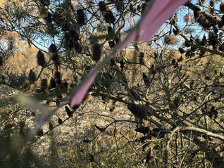
Below: 31-05-2025. The FFMV pink tape marks a New Holland Mouse and White-footed Dunnart location
New Holland Mouse and White-Footed Dunnart Site Two
GEG surveyors mapped the excluded area at this New Holland Mouse location. Only 0.9ha area was excluded from burning. The record was not in the centre of the excluded area. The burn was ignited immediately adjacent to the record location. Burns and Phillip (2020) recommends that if a planned burn is unavoidable, an exclusion area of 3ha surrounding the record location should be excluded from fire in any planned burn.
Below: 31-05-2025. The FFMV pink tape marks a New Holland Mouse and White-footed Dunnart location.
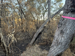
White-footed Dunnarts (FFG VU)
Two other White-footed Dunnart record sites within the burn area were completely incinerated.
White-footed Dunnarts require forest and woodland cover of more than 50% of any square metre of heath understory or mid-story plant species. Other habitats include coastal tussock grasslands, sedgeland and wet heath. This dunnart has an individual range of about 120 square metres for both sexes, although this varies greatly among males, with some males acquiring territories of up to 1200 square metres. Male territories often overlap those of females. Sminthopsis leucopus : White-Footed Dunnart | Atlas of Living Australia
According to the White-footed Dunnart Action Statement: Frequent and/or intense fire can lead to direct mortality, habitat degradation, the loss of ground refugia and nesting habitat, and increase predation risk, particularly by feral cats and foxes until the vegetation recovers. Fire management operations such as creation of fuel breaks (soil disturbance, slashing) may cause mortality of individuals, remove habitat and reduce regeneration.
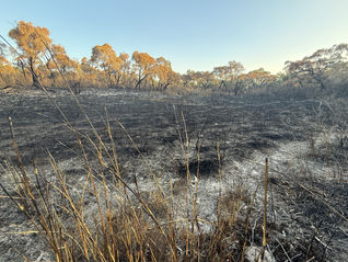
Below: 31-05-2025. White-footed Dunnart locations completely incinerated. 360 degrees photo taken from Dunnart location one

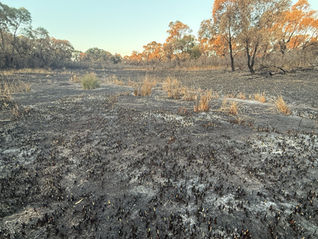
Below: 31-05-2025. FFMV pink tape at left of image marks the White-footed Dunnart location. 360 degrees photo taken from Dunnart location two

Exposed Swamp Rat, Rattus lutreolus burrows in incinerated Sedge Wetlands
Exposed Swamp Rat, Rattus lutreolus burrows leaving them vulnerable to predation, if they haven’t been destroyed in the fire. The species tends to choose the habitat based on density of vegetation in the area. Areas prone to fire tend not to be recolonised. This incinerated habitat is Sedge Wetlands, itself a threatened EVC
Below: 31-05-2025. Swamp Rat burrows exposed and Sedge Wetland incinerated

Across the burn area, the fire destroyed old hollow trees
Across the burn area, the fire has destroyed old slow growing hollow-bearing Gippsland peppermints, and damaged the canopy over large areas.
Below: Photos 19-05-2025 of some of the many collapsed old trees throughout the burnt area

Across the burn area, the fire destroyed old banksias
Large banksias are a keystone species, the loss of banksias has a flow-on effect to other inhabitants of the ecosystem. They flower mostly in summer and autumn, rather than spring, significantly expanding the period of availability of nectar. They produce large woody seed cones, if unburnt provide year round food for a whole range of species.
They are a major source of food for Grey-headed flying-foxes, honeyeaters, spinebills, wattlebirds, lorikeets and eastern pygmy-possums, as well as a large number of nectivorous invertebrates upon which insectivorous vertebrates will feed. Fauna supported by banksia woodlands consists of large browsers such as wallabies, wombats, and other mammals and marsupials such as bandicoots, echidnas, antechinus, native rats and mice, small and medium-sized arboreal marsupials such as eastern pygmy-possums, gliders, possums and micro bats.
Below: Photos 19-05-2025. Some of the many old saw banksias collapsed in the burn area
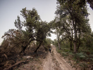
Fire burnt right through swamps and Sedge Wetlands EVC 136 (Bioregional Conservation Status VU)
Below: 19-05-2025 to 31-05-2025


Along the entire burn perimeter, felled and bulldozed old habitat trees
GEG surveyors counted over fifty trees in the Reserve that had been felled or bulldozed on the entire perimeter of the 'treated' 46ha burn area.
Below: Photos 19-05-2025

Take Action
Ask for independent oversight and protection of biodiversity in planned burns
Parks and Reserves take up around 50% of the state's planned burn targets. There is no protection for biodiversity, habitat or threatened species in planned burns, even within Parks and Reserves.
Fire management planning is happening, without independent oversight with the Department self-assessing and evaluating their own operations. FFMV do not monitor the efficacy of their planned burns in preventing bushfires.
In Victoria there is no mandatory Code for protection of biodiversity values in planned burn operations that takes into account obligations under the EPBC Act
There is no publicly available information on how operations are planned and how impact on threatened species is minimised and avoided
FFMV do no on- ground pre or post-burn survey for fauna, flora or habitat
FFMV rely on desktop data from the Victorian Biodiversity Atlas in planning which is outdated and does not show most recent records. This was highlighted by the Victorian Auditor-General’s Office’s report Protecting Victoria’s Biodiversity (2021)
According to the Victorian Auditor General’s report Reducing Bushfire Risks. Victorian Auditor General (2020). “With the exception of some isolated case studies, DELWP does not know the effect of its burns on native flora and fauna”
Re efficacy of planned burns in preventing bushfires:
“We’ve understood for a long time now that logging can make bushfires worse, but it’s only in the last few years that evidence is showing that prescribed burning could be doing the same thing,” lead researcher Professor David Lindenmayer, ANU
Contact those responsible
Ask them to put independent oversight in place and regulate impacts using up-to-date science.
You can send also send an email HERE https://vnpa.org.au/action-minister-give-native-forests-proper-oversight/
Steve Dimopoulos MP – State Min for Environment
Email: reception.dimopoulos@ecodev.vic.gov.au
Phone: 03 862 43101
Jacinta Allan – Premier of Victoria
Email: jacinta.allan@parliament.vic.gov.au
Phone: 03 9651 5000
Vicki Ward Minister for Emergency Services
Email: vicki.ward@parliament.vic.gov.au
Phone: 1300 358 704
Murray Watt – Federal Min for Environment
Email: Minister.Watt@dcceew.gov.au
Phone: 02 6277 7920
Office of Conservation Regulator, Kate Gavens
Email: conservationregulator@deeca.vic.gov.au


