Gippsland Environment Group Inc
Lobbying against environmental threats on the unceded lands of the GunaiKurnai, Yaitmathang, Ngarigo and Bidwell Peoples
Mitchell River National Park
Total planned burn area: 1876 hectares
Ignited 19 April 2025 - Southern Section Surveyed May 2025
Mitchell River National Park - Calvi Track GP-TBO-BAI-0163
GunaiKurnai Country
The Mitchell River National Park is listed in Category II (National Parks) of the International Union for the Conservation of Nature protected area categories and the United Nations’ List of National Parks and Equivalent Reserves.
Category II areas are large natural or near natural areas set aside to protect large-scale ecological processes, along with the complement of species and ecosystems characteristic of the area, which also provide a foundation for environmentally and culturally compatible spiritual, scientific, educational, recreational and visitor opportunities.
The Park protects an rich landscape of cultural and ecological values, many of which are Matters of National Environmental Significance.
The Gunaikurnai Land and Waters Aboriginal Corporation state that “The deeply incised Mitchell River Gorge is a spectacular landscape, and the topography includes narrow sheltered gullies supporting rare vegetation types such as dry rainforest, warm temperate rainforest and gallery rainforest”
Below: Top of Roaring Mag Falls, within the burn site, looking west to the Mitchell River Valley. Photo Louise Crisp

Environment Groups requested burn be removed due to impact on ecological values
Gippsland Environment Group and Victorian National Parks Association wrote to DEECCW-EPBC Compliance requesting the burn be removed due to the impacts on Matters of National Environmental Significance (MNES) with some of those values being: Southern Greater Glider (Petauroides volans); Yellow Bellied Glider (Petaurus australis), Gang Gang Cockatoo (Callocephalon fimbriatum), Giant Burrowing Frog (Heleioporus australiacus)Dry rainforests of south east New South Wales and East Gippsland, and a formally recognised Protected Area.
Much of the 1876ha burn area is steep and inaccessible and has never been thoroughly surveyed. And it's a long way from any built or privately owned assets.
On 19 April, during Easter school holidays, Forest Fire Management Victoria (FFMV) ignited the burn.
According to the FFMV website (07-05-2025), only 500ha of the planned 1876 ha has been ‘treated’ and that FFMV intend to burn the remainder. https://plannedburns.ffm.vic.gov.au/burn-site/3010032
As 500 ha has already now been burnt here by FFMV, predominantly on ridgelines and significant damage has already occurred, we are asking that no more fire is put into this planned burn site.
Six days after ignition
The Park is thick with smoke
Mitchell River National Park 20-04-2025 six days after ignition; Wattle Creek Rd; Other photos from Sandy Creek Rd Bridge, looking south-west to Sandy Ridge Tk in the southern burn area.

Post burn surveys - May 2025
During May 2025, Gippsland Environment Group undertook post-burn surveys in the southern section of the burnt area. Much of the burn area is un-surveyed with steep ravines and cliffs supporting slow growing and rare vegetation, rainforest gullies, riparian zones and old growth forest.
Trees were observed still burning after three weeks and over 40mm of rain. We are concerned that if this burn had been ignited in drier conditions, the damage would be extreme and far ranging.
Southern Escarpment above Roaring Mag Creek
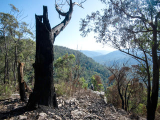
The fire burnt right to the edge of the escarpment and in places, descended over the cliff. Fire destroyed old hollow trees, fire sensitive Black she-oaks and slow growing vegetation on the edge of the cliffs. In some places the fire was so hot that it shattered rocks.
Below: The southern escarpment above Roaring Mag Ck. Cliff photos show crown scorch on the southern escarpment with view from the northern escarpment

Collapse of old hollow trees
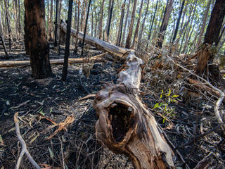
Fire caused significant damage and subsequent collapse of many large old hollow trees across all burnt areas surveyed. Fire is a threatening process to many tree-dwelling species, not only causing direct mortality, but also the destruction of habitat trees used for nesting, feeding and denning. Research by DELWP Report No:95 (Bluff 2016) identified that hollow bearing trees in planned burns were 28 times more likely to collapse than in unburnt areas. The research also found that fire damage to hollow trees was cumulative. If an old hollow tree survived the first fire, basal damage would ensure that the second or third fire, would take them out.
Below: Southern section of burn area May 2025

Significant Areas of crown scorch
Below: On the plateau north off Roaring Mag Road

New Bulldozed Tracks in the Park
GEG surveyors followed a new bulldozed track that had been driven into the bush off Roaring Mag Rd and down to the edge of a tributary gully and continued halfway to the escarpment. The bulldozing and the burning caused damage to large old trees, including around the base of large Yellow-bellied glider feed tree.
Below: New bulldozed track off Roaring Mag Tk May 2025

New records of rare Wallaby bush
The fire entered the edge of a grove of rare and previously unrecorded Wallaby Bush Beyeria lasiocarpa (VU) and two plants were killed. Other new records of Wallaby Bush were identified within the targeted burn area.
Below: May 2025

Roadside Habitat trees Targeted
Large old hollow bearing trees along Sandy Ridge Tk appear to have been deliberately targeted for ignition. Some very large old hollow bearing trees have been destroyed, and some have been seriously weakened. After 3 weeks and over 40mm of rain, fires are still smouldering.
Below: Sandy Ridge Tk. May 2025

Habitat trees cut down and bulldozed on the side of tracks
Old hollow trees have been bulldozed and cut down on the side of tracks within the burn area
Below: Sandy Ridge Tk and Roaring Mag Rd. May 2025

Take Action
The FFMV website states only 500ha of the planned 1876 ha has been ‘treated’ and that FFMV intend to burn the rest. https://plannedburns.ffm.vic.gov.au/burn-site/3010032
As 500ha has now been burnt by FFMV, mostly on ridge-lines and significant damage has already occurred,
we strongly advise that no more fire is put into this planned burn site.
Ask for independent oversight and protection of biodiversity in planned burns
Parks and Reserves take up around 50% of the state's planned burn targets. There is no protection for biodiversity, habitat or threatened species in planned burns, even within Parks and Reserves.
Fire management planning is happening, without independent oversight with the Department self-assessing and evaluating their own operations. FFMV do not monitor the efficacy of their planned burns in preventing bushfires.
In Victoria there is no mandatory Code for protection of biodiversity values in planned burn operations that takes into account obligations under the EPBC Act
There is no publicly available information on how operations are planned and how impact on threatened species is minimised and avoided
FFMV do no on- ground pre or post-burn survey for fauna, flora or habitat
FFMV rely on desktop data from the Victorian Biodiversity Atlas in planning which is outdated and does not show most recent records. This was highlighted by the Victorian Auditor-General’s Office’s report Protecting Victoria’s Biodiversity (2021)
According to the Victorian Auditor General’s report Reducing Bushfire Risks. Victorian Auditor General (2020). “With the exception of some isolated case studies, DELWP does not know the effect of its burns on native flora and fauna”
Re efficacy of planned burns in preventing bushfires:
“We’ve understood for a long time now that logging can make bushfires worse, but it’s only in the last few years that evidence is showing that prescribed burning could be doing the same thing,” lead researcher Professor David Lindenmayer, ANU
Contact those responsible
Ask them to put independent oversight in place and regulate impacts using up-to-date science.
You can send also send an email HERE https://vnpa.org.au/action-minister-give-native-forests-proper-oversight/
Steve Dimopoulos MP – State Min for Environment
Email: reception.dimopoulos@ecodev.vic.gov.au
Phone: 03 862 43101
Jacinta Allan – Premier of Victoria
Email: jacinta.allan@parliament.vic.gov.au
Phone: 03 9651 5000
Vicki Ward Minister for Emergency Services
Email: vicki.ward@parliament.vic.gov.au
Phone: 1300 358 704
Murray Watt – Federal Min for Environment
Email: Minister.Watt@dcceew.gov.au
Phone: 02 6277 7920
Office of Conservation Regulator, Kate Gavens
Email: conservationregulator@deeca.vic.gov.au


